Tuesday, March 31, 2020

Chinas Railway for Laos: Fast Railway Building between Yuxi and Mohan in Yunnan

See the locations on Yuxi-Mohan railway 玉磨铁路 Google Map by #chineselaosrailway

The Yuxi–Mohan railway 玉磨铁路 or Yumo railway is under construction in Yunnan Province in southwest China. The line will run for 503.9 km from Yuxi West station 玉溪西站 in central Yunnan to Mohan in Mengla County in the Xishuangbanna Dai Autonomous Prefecture - on the border with Laos, where it will join Chinas Railway for Laos an complete the railway conncection from Kunming to the border of Thailand near Vientiane. The railway will be electrified, and will have double-track from Yuxi to Jinghong and single-track from Jinghong to Mohan.

It is difficult to find detailed informations about the progress of this railway line. But we did a lot of research and present it here:


Planned are 13 intermediate stations: Yuxi West, Yanhe, Eshan, Luoli, Yuanjiang, Mojiang, Ninger, Puer, Mengyang, Xishuangbanna 西双版纳站, Ganlanba, Mengla, Mohan. The project counts 22 main sections and several contracts and packages:


Section 1 (YMZQ-1): China Railway 6th 中铁六局. It starts from Yuxi west and ends with Hele tunnel No. 1 和乐隧道一 slope. Length: 17.685 km, including 5 bridges (1383.99 m), 4 tunnels (8125 m). Most important: The construction of Dinggu double-line bridge 定古双线大桥2 (487.57 m, see picture) and Hele tunnel 和乐隧道 (4451 m part of 7922 m, see picture). Yanhe 研和站位 station in the south of Yuxi City has been opened. First it will facilitate the transportation and transit of the materials needed for the subsequent laying of rails and girders. Later it will become a logistics center. Read more.
Hele tunnel: Holed through, see picture.


Section 2 (YMZQ-2): It starts from Hele tunnel No. 1 和乐隧道一 slope and ends in Luoli Tunnel 罗里隧道贯 breakthrough point. Length: 29.558 km, including road bed (3965 m), 4 bridges (923.9 m), 5 tunnels (27284 m), construction of Eshan station 峨山站 and Luoli station 罗里站. Most important: The construction of Hele tunnel 和乐隧道 (Slope end part-tunnel exit, 3471 m) and Wanhe tunnel 万和隧道 (17441 m).
Wanhe tunnel has been holed through on March 13 2020 according to the China Railway Kunming Group Co, Ltd. Constructed by China Railway 12th Bureau Group Co., Ltd.. It is located in Eshan County. With a maximum burial depth of 586 m and a minimum burial depth of only 5 m the tunnel passes through two large faults. The construction was accompanied with frequent gushing mud and water, with the maximum daily water gushing reaching 64,000 cubic meters. It underpasses Kunming-Mohan Expressway (read more) and see picture.


Section 3 (YMZQ-3): China Railway tunnel 中铁隧道. It starts from Luoli Tunnel 罗里隧道 breakthrough point and ends in Yueyatian tunnel 月牙田隧道2 Slope end point (see picture). Length: 28.242 km, including road bed (167 m), 3 bridges (1247.12 m), 4 tunnels (25338 m), railway stations. Most important: The construction of Fatushan double-lines bridge 法土山双线大桥2 (185.40 m, see picture), Lixinzhai Four-lane bridge 立新寨四线特大桥4 (976 m, see and read, see picture), Yangwu tunnel 杨武隧道 (14835 m, see picture), Lixin tunnel (5317 m). Lixinzhai Four-lane bridge has 24 spans and a maximum span of 80 meters. The highest pier is 71.9 meters and the deepest pile is 60 meters. There is a crossing station on the bridge. It crosses Kunming-Mohan Expressway.
Fatushan bridge has been closed on October 1 2018, read. One end is connected to Luoli Tunnel 罗里隧道, the other end to Tianfang tunnel 田房隧道. Constructed by China Railway Tunnel Bureau Group 中铁隧道局集团.
Lixinzhai four-line bridge is 952,8 m long.


Section 4 (YMZQ-4): It starts form Yueyatian tunnel 月牙田隧道2 Slope and ends at Qiaotoucun 桥头村2 tunnel entrance. Length: 33.079 km, including roadbed (7852 m), 3 bridges (712.03 m), 4 tunnels (24515 m), construction of Yuanjiang railway station 月牙田隧道2. Most important: Eshan tunnel 峨嘎山隧道 (see), Ganzhuang tunnel 甘庄隧道 (see). Yueyatian Tunnel 2 月牙田隧道2.


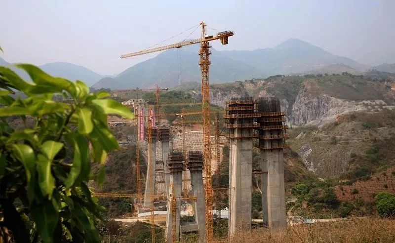
Section 5 (YMZQ-5): China Railway 4th 中铁四局. It starts from Xiaotou Village 2 tunnel 桥头村2#隧道 entrance and ends at Xincun 2 tunnel 新村2#隧道 entrance. Length: 6.014 km, including section roadbed (47 m), station roadbed (425 m), 3 complex huge bridges (2370 m), 5 bridges (1944 m), 2 tunnels (1525 m). Most important: Yuanjiang Double Line Super Bridge 2 元江双线特大桥2 元江特大桥刷新世, Nanxi River Four Line Super Large Bridge 4 南溪河四线特大桥4. Dakaimen River Double Line Bridge 2 大开门河双线大桥2, Amo river double line railway bridge 阿墨江双线特大桥, Jinghong Yongjiang Double-track Bridge 2 景洪澜沧江双线大桥2 (see picture), Babianjiang double line railway bridge 把边江双线大桥2. Nanxi river station 南溪河站.
In Juni 2018 workers began to lay the first steel truss complex on Yuanjiang Railway Bridge 元江特大桥刷新世, which ist 832,2 m long and has the tallest bridge pier in the world (154 meters high) and the longest span between two piers. The bridge spans the Red River (Honghe River) Canyon. It is a steel truss bridge with height of 238 meters. There are 4 bridge piers. Read more. Sometimes temperatures were 40 degree and steel got more than 60 degres hot, as you can read here. See pictures from April 2020. In July the bridge was closed. See pictures.


Nanxi River bridge 南溪河特大桥: See pic. The bridge construction was closed in September 2020.


Babianjiang double line bridge  (421.5 meters main pier 86 meters high): In March 2019 the fundation has been finished. See pichttp://two.crec4.com/content-89-1971-1.html.
Amo river double line bridge (617 m long): Two main piers are 89,5 m high, there are seven piers. The river is 334 m wide. Read more on Construction Times.and read here. See more pictures. See video.
Both sides of the bridge have been connected in October 2020:


Section 6 (YMZQ-6): China Railway 5th 中铁五局.  It is located in the West of Mo River. From Xincun 2 tunnel entrance 新村2#隧道进口 to Anding tunnel 安定隧道3 (see). Length: 24.986 km, including roadbed (155 m), 3 bridges (454.15 m), 6 tunnels (24382 m). Most important: The construction of Tongda tunnel 通达隧道 (11298 m) and Anding tunnel 安定隧道 (8822 m).
Anding tunnel is located at the junction of Yuanjiang County and Mojiang County. It crosses Ailao Mountain. It passes through 20 faults and 2 syncline structures, karst and soft rock, has gushing water and there is high geothermal heat. It is near the collision zone between the Indian Plate and the Eurasian Plate. Inclined shaft has been holed through in June 2019. Picture. The 17.5-km-long Anding Tunnel has been drilled through end of November 2020. See video.


Section 7 (YMZQ-7): Built by China Railway 19th Bureau 中铁十九局. It is located between Nanxi river station 南溪河站 and Thalang river station 他郎河站, starting from Anding tunnel 3 slope, ending in Wanggang mountain tunnel 2 王岗山隧道2 slope. Length: 19.935 km, including station roadbed (1471200 sq.m.), 2 tunnels (18400 m), 1 complicated bridge (143.2 m), 1 bridge (506.79 m), highway bridge (48.55 m). The section crosses 213 national road and Shuigui River bridge 水葵河大桥. Most important: The construction of Anding tunnel and Wanggang mountain tunnel. Includes Ping'an tunnel 平安隧道.
Wanggang Mountain tunnel (13,5 km): Should be completed End of May 2020. Read.
Nanxi River Extra Large Bridge 南溪河特大桥: See construction on March 09 in 2020. See also these pictures, and this video.


The construction of Mojiang section railway station 墨江段火车站点施 is progressing steadily. see pictures.


The Pu'er section 普洱段全长 is 156 km long, has 16 tunnels and 278 bridge piers:

Section 8 (YMZQ-8): It is located in Mojiang country, Pu'er city. It starts from Wanggang mountain tunnel 2 slope 王岗山隧道2, ending in Xinhua tunnel 1 新华隧道1 Horizontal hole ending point. Length: 20.893 km, including demolition and land expropriation project, 1 bridge (109 m), 3 tunnels (20762 m), railroad track (36.938 km). Most important: Wanggangshan Tunnel 3 王岗山隧道3, The construction of Talang river 4 line bridge and Duoji tunnel 多吉隧道.
Duoji tunnel is 14,539 km long. Entrance penetrated in Dezember 2017, read. The tunnel was drilled through in August 2020, see picture.


Section 9 (YMZQ-9): Located in Mojiang country, Pu'er city. It starts from Xinhua tunnel 1 Horizontal hole 新华隧道1#横洞 and ends in Shitou zhai 2 slope 石头寨2#斜井终点. Length: 20.482 km, including 2 tunnels (20375 m), 1 middle bridge (94.25 m), roadbed (131550 cubic meter). Most important: The construction of Xinhua tunnel 新华隧道1#横洞终点 (13384 m) and Shitou zhai Tunnel (6991 m) 石头寨特长隧道整体, read. There was an accident during construction with five dead people, read.


Section 10 (YMZQ-10): China Railway 10th 中铁十局. Located in Mohei town, Pu'er city. Length: 22.405 km, including 4 tunnels (20747 m), 4 bridges (903.36 m), roadbed (17309 cu.m), railway station (302000 cubic metres). Most important: Dajinshan double-line middle bridge 2 大金山双线中桥2, Grinding black four-line bridge 4 磨黑四线大桥4, The construction of Shitou Zhai tunnel (4851 m) and the Dajinshan Tunnel 大金山隧道 (10657 m). Puma river fourth line bridge 朴马河四线中桥.


Section 11 (YMZQ-11): Located in Ning'er country 宁洱, Pu'er city. From Peace Tunnel 和平隧道进 Entrance to Taida Village Tunnel 太达村隧道进 Entrance. Length: 20.74 km, including roadbed (3398 m), 8 bridges (3989 m), 4 tunnels (9575 m), Ning'er station 宁洱站. Most important: Ninger double line bridge 宁洱双线特大桥2 (802 m) and Heping tunnel 和平隧道长 (8847 m).
Ning'er station: See picture.
Ning'er double line bridge: See pictures.


Section 12 (YMZQ-12): China Railway 18th Bureau 工的中铁十八局集. Located in Ning'er country, Pu'er city. From Taida Village Tunnel 太达村隧道 (5815 m) Entrance to Sanjia Village Tunnel 三家村隧道出 Exit. Length: 25.285 km, including roadbed (218.83 m), 5 bridges (765.17 m), 6 tunnels (24301 m), ballastless track bed (28314 m). Most important: The construction of Dajianshan Tunnel 大尖山隧道 (14187 m) and Nasu river double line bridge 那苏河双线大桥2 (329.51 m), Taidacun tunnel (5815 m).
Sanjia Village tunnel (3470 m) was holed through in November 2019. Read and see and see here.
Dajianshan Tunnel 大尖山隧道: Entrance completed in November 2019, read and see.
Nasu river bridge: See pictures.


Section 13 (YMZQ-13): China Railway 8th 中铁八局. Located in Pu'er city, starting from Sanjia Village Tunnel to Maliping Tunnel (5639m) Entrance 麻栗坪隧道进. Haizi Tianjing Baisha slope via Xinfang reservoir. Length: 19.202 km, including roadbed (3.101 km), 15 bridges (3126.16 m), 14 tunnels (12975 m). Construction of Pu'er railway station 普洱火车站. Most important: Mu Nai river double line bridge 木乃河双线特大桥2 (1173.35m).
Pu'er station 普洱火车站 is about two kilometers from Simao.


Mu Nai river double line bridge: 1173.35 m. See picture1 and picture 2. The bridge was completed in July 2020.


Maliping tunnel is connected to Mu Nai river. See picture and also picture.
Dingjiaqing No. 1 tunnel 丁家箐1号隧道 (338 m). The entrance of the tunnel is close to the 309 provincial highway, the exit is closer to the expressway. See picture.
Dingjiaqing No. 2 tunnel 丁家箐2号隧 (153 meters).
Laowangzhai No. 1 tunnel 老王寨1号隧 (208 meters), holed through in april 2019, read.
Sankezhuang No. 1 tunnel 三棵庄1号隧 (295 meters)


Section 14 (YMZQ-14): China Railway Shanghai 中铁上海局. Located between Pu'er and Xishuangbanna, starting from Maliping tunnel ending point 麻栗坪隧道进, ending in Huigang mountain tunnel (8903 m) 会岗山隧道出 exit. Length: 25.192 km, including roadbed (1.778 km), road moving project, 3 bridges (295.35 m), 4 tunnels (23.119 km). Puwen station 普文站. Most important: The construction of Huipai mountain tunnel (7475 m) 会排山隧道长 and Huigang mountain tunnel 会岗山隧道.
Huipai mountain tunnel: Holed through in April 2020. See picture and read.
Puwen tunnel 普文隧道: 2232 m. See video.
Sanjian river double line bridge 三涧河双线中桥:
Lazi river double line bridge 分别为腊子河双线中桥:


Section 15 (YMZQ-15): Located in Jinghong, Xishuangbanna. From Huigangshan Tunnel 会岗山隧道出 Exit to the middle of Dabaishu Tunnel 大白树隧道中. Length: 19.785 km, including roadbed (8.352 km), 20 bridges (7.184 km), 6 tunnels (4.249 km), 35 culvert (1.008 km). Most important: Datuan Mountain Tunnel 大团山隧道, Big white tree tunnel 大白树隧道. The Datuan Mountain Tunnel is located in Jinghong City, Xishuangbanna Dai Autonomous Prefecture. It has a total length of 2,105 meters and is a two-lane tunnel, penetration has taken place in July 2018. No. 1 Huangzhulin Tunnel 黄竹林1号隧道 was finished in Dezember 2019 (see Youtube). The Huangzhulin tunnel cluster consists of the No. 1, No. 2 and No. 3 tunnels. Each of them passes through a mountain and the three tunnels are located on a curve with a radius of 2,800 metres.

Section 16 (YMZQ-16): China Railway 3rd 中铁三局. Located in west of Jinghong, Xishuangbanna. From the middle of Dabaishu Tunnel 大白树隧道中 to Xishuangbanna Tunnel 1 西双版纳隧道1 . Length of 21.346 km, including roadbed (2142 m), 1 bridge (43.7 m), 3 tunnels (19161.6 m), construction of Yexiang valley station 野象谷车站 (wild elefant valley, see Youtube-video) 野象谷. Most important: The construction of Mengyang tunnel 勐养隧道 (13539 m) and Xishuangbanna tunnel 西双版纳隧道进 (4137.6 m).
Mengyang tunnel: See picture. The 13,5 km-tunnel was drilled through on December 5 in 2020. The 13.5-km tunnel was constructed under the Wild Elephant Valley.


Xishuangbanna tunnel: See picture.

Section 17 (YMZQ-17): Located in Jinghong, Xishuangbanna. From Xishuangbanna Tunnel 1 西双版纳隧道1 End Point to Nanlian Mountain Tunnel 南联山隧道进 Entrance. Length: 14.7 km, including construction of Xishuangbanna railway station 西双版纳站, 3 bridges (3069.63 m), 2 tunnels (7610 m), interval roadbed (3297.79 m), station roadbed (3335.917 m), 15 culverts. Most important: Xishuangbanna station 西双版纳车站. Xishuangbanna Double Line Bridge 2 西双版纳双线特大桥2.

Section 18 (YMZQ-18): Located in Xishuangbanna. From the entrance of Nanlian Mountain Tunnel 南联山隧道进 to Manle No. 2 tunnel 曼么二号隧道进 entrance. Length: 38.878 km, including 8 bridges (5987.66 m), 9 tunnels (27822 m), road moving (5.3 km). Most important: Olive Dam Station 橄榄坝站. Olive Dam Bridge 橄榄坝特大桥. Hot spring village bridge 温泉村大桥. Nanlian Mountain Tunnel 南联山隧道长. Southern Lianshan Tunnel 南联山隧道, Bach Tunnel 巴奇隧道, Jingkuan No. 1 Tunnel 景宽1号隧道 and Jingkuan No. 2 Tunnel 景宽2号隧道.
Jinghon Hanhan Beam 景洪勐罕制梁 site has been constructed for pouring T-beam elements for Yuxi-Mohan railway. Read and see.
Olive Dam Bridge has been erected already, read and see.
Jingkuan No 2 Tunnel 景宽2号隧道 (4600 m) has been holed through in April 2020. Read and see.


Section 19 (YMZQ-19): Located in Mengla County, Xishuangbanna. From Manle No. 2 tunnel 曼么二号隧道进 to Baluo 2 Tunnel 巴罗二号隧道进. Length: 27.5 km, including 6 tunnels (25462 m), 7 bridges (1664.33 m), roadbed (2319.4 m). Construction of Suoluo River crossing station 梭罗河站, Nanban River Bridge 南班河大桥, construction of Guanlei crossing station. Mantra bridge 曼腊特大桥. Manmushu tunnel 曼木树隧道长 (11638m).

Section 20 (YMZQ-20): Project located in Mengla County, Xishuangbanna. From Baluo 2 tunnel 巴罗二号隧道进 to Manzhang 1 bridge 曼掌1号大桥. Length: 36.957 km, including roadbed (2.445 km), 13 bridges (4.413 km), 8 culverts (188.2 m), 6.5 tunnels (30.089 km), 3 railway stations. Most important: Mengyuan Station 勐远站, Manle Station 曼勒站, Kailu North Station 缓开勐腊北站. Manle 1 tunnel 曼勒一号隧道, the construction of Mengla tunnel 勐腊隧道, located in the area between Manle and Mengla, with a total length of 13018m (read more).

Section 21 (YMZQ-21): Located between Mengla County and Shangyong County, Xishuangbanna. From Manzhang No. 1 Bridge 曼掌1号大桥 end to Dongfanghong Bridge Yuxi 东方红大桥玉溪端 end. Length: 26.01 km, including roadbed (5737 m), 16 bridges (6001.63 m), 5 tunnels (14993 m), construction of Mengla railway station 勐腊站 and Big Longha railway station. Most important: Mengla station 勐腊站, which is connected with Manmai 1 Tunnel 曼迈一号隧道贯 (see picture), Shanggang Bridge 2 上龙茵特大桥2, Mengla South Dawo River Bridge 勐腊南大窝河大桥, Wang Silong Bridge 王四龙特大桥, Shanggang No 1 tunnel 尚岗一号隧道 (see picture). The construction of Moxie huge bridge, Mannasang Bridge and Na River No.1 bridge 纳江一号大桥.
Manzhang tunnel 曼掌隧道 (1730 m) has been completed by China Railway's Kunming bureau in October 2019. See picture. Manmai 1 Tunnel was completed in May 2020.

Section 22 (YMZQ-22): China Railway 2nd 中铁二局. Project located in Mohan Cross-border Cooperation Zone, Xishuangbanna. From Dongfang Red Bridge Yuxi Duan 东方红大桥玉溪端 to Friendship Tunnel 友谊隧道. Length: 14.159 km, including roadbed (4168 m), 8 bridges (2821.63 m), 1 tunnel called Friendship tunnel 友谊隧道 (7170 m), construction of Mohan north railway station 磨憨口岸站 磨憨北站 and Mohan railway station 磨憨站. Mohan Beam field 磨憨梁场. Friendsjip tunnel has been drilled trough in September 2020.
Source: zawya.com and blog.sina.com.


Read regular updates: Chinas Railway for Laos

Monday, March 30, 2020

Laos and Coronavirus: People have to stay at Home, Border Checkpoints closed


Luang Prabang, 29.3.2020: Streets quiet, people hat home after lockdown by governent due to Coronavirus Picture by In Laos ໃນເມືອງລາວ on Facebook

Follow Updates on Treasures of Laos on Facebook


31.3.2020
Vientiane bus suspends all services as virus prevention measure. Also in Bokeo prince public transport has been suspended.


30.3.2020
The Lao government said all international checkpoints will be closed to stop passengers from exiting and entering Laos, as the country imposed a lockdown to prevent the spread of the coronavirus, reports Xinhua. The transport of goods will, however, be permitted. People from all walks of life, including expatriates in Laos, are not allowed to go out of their homes or other accommodation for non-essential purposes. The measures will be in place from Monday (March 30) to April 19 and further changes could be made, local daily Vientiane Times reported on Monday. Read the report by Vientiane Times. Five patients are being treated at Mittaphab Hospital in the capital, and three are being cared for at Luang Prabang provincial hospital (see Facevook Page). "Outbreak fears in Laos escalated after thousands of Lao workers in neighbouring countries, especially Thailand, where a widespread outbreak was reported, have rushed home", writes Vientiane Times. Entertainment venues, karaoke, beer shops, night markets, massage and spa service venues, witness or sporting centres were told to close down.
Another case of Covid-19 infection has been confirmed in Vientiane Capital, bringing the total number of cases in Laos to nine. A 22-year-old woman, one of the thousands of Lao laborers who have returned from Thailand, has been tested positive, reports Laotian Times


26.3.2020
The number of cases of coronavirus infection in Laos have doubled overnight, an official with the country’s Ministry of Health said Thursday, bringing the total to six, reports rfa.org. The two new cases are two male tour bus drivers, aged 42 and 52, from Luang Prabang city who had close contact with a female, aged 36, who works as a guide for European tourists and was confirmed as one of the country’s first two infections on Tuesday, along with a 28-year-old male working in management at the Crowne Plaza Hotel in the capital Vientiane. The third new case—a 41-year-old male in Vientiane—had close contact with a 26-year-old male businessman who on Wednesday was confirmed as the third case and had become infected after having dinner with the Crowne Plaza Hotel employee.


25.3.2020
Kiridara Luang Prabang informs on Facebook: "The temporary suspension of all international flights into Luang Prabang and border closures due to the Covid-19 situation have caused hotels in Luang Prabang to temporarily cease operations."


23.3.2020
Chinese workers, some from a company in Wuhan, have restarted works for the construction of China-Laos railway, precautions are taken against coronavirus. Read more here.


3.2.2020
Chinese national carrying coronavirus travelled through Laos: The Laotian Times obtained a document from Chinese consulate in Luang Prabang. This document announced that Zhang Biao, a Chinese national from Chongqing (southwest China), had been discovered to have been infected with the coronavirus during his travel to Laos. In the evening of the 26th of January, Mr Zhang traveled to Vientiane Capital on China Express Airlines (flight G52805) as part of a group tour. He then proceeded to go to Vang Vieng on the 27th and reached Luang Prabang on the evening of the 28th. He then returned to Chongqing on the 31st via China Express Airlines (flight G54856).


Thursday, March 26, 2020

Another controversial Mekong Dam in Luang Prabang raises Fears

See the location on Luang Prabang Google Map by #treasuresoflaos

Update 26.12.2020
Construction of the controversial Luang Prabang Dam on the Mekong River, near the ancient Lao capital of the same name, is making progress, as rfa.org reports. Access roads, including a 14-kilometer spur to the dam from a nearby highway and a road that circles the site, are nearly 60 percent complete, a new ferry port was recently finished, and a workers’ camp and bridge spanning the Mekong are underway. An expected 581 families will be displaced. The Project site is located on the Mekong River approximately 25 km upstream of Luang Prabang town at the village Ban Houaygno and about 4 km upstream of the confluence between Nam Ou and the Mekong. See details on Hobomaps.

In November 2020 Thailand-based CK Power Public Company Limited acquired 42% of Luang Prabang Power Company Limited (LPCL) from PT (Sole) Company Limited (PTS), reports kaohoon.com from Lao investment company PT (Sole) Company Limited (PTS). In December CKP has entered into capital increase in its shareholding proportion in LPCL.


Update 26.3.2020
Thailands Deputy Prime Minister Prawit Wongsuwon raises concerns over Luang Prabang dam: He calls for international efforts to monitor the controversial Luang Prabang dam project in Laos and the impact it will have on the Mekong River, where water levels have been unusually low.


13.1.2020

Luang Prabang Dam - illustration in MRC project overview

Vietnam's rice bowl, the Mekong Delta, severly damaged? Luang Prabang World heritage town inundated and destroyed? Such fears have been raised, after the Lao government has announced another massive dam project on Mekong river: the Luang Prabang dam. Laos has formally notified the Mekong River Commission (MRC) of its intention. The 1460 MW Luang Prabang dam is the fifth dam to be submitted for consultation. The earlier hydropower projects were Xayaburi (operational now), Don Sahong (in the final testing phase), Pak Beng and Pak Lay.

Luang Prabang dam is planned approximately 25 km upstream of Luang Prabang ancient town, at the village Ban Houaygno, and about 4 km upstream of the confluence between Nam Ou and Mekong, with a 90 sq km reservoir. The Luang Prabang Power Company Limited (LPCL) has been established to develop the project by PetroVietnam Power Corporation (PV Power). Petrovietnam Power Corporation is a subsidiary of Vietnam Oil and Gas Corporation. The dam will have a navigation lock so that boats still can navigate up- and downstream. Fish could use two fish locks as well as the ship lock to migrate upstream. To protect Luang Prabang town from the flood of a dam failure the structures shall be designed to withstand extreme seismic and flood events. That is necessary: Luang Prabng province is located in a high earthquake hazard region.


Illustration in MRC project overwiew

The US$ 2,000 million project is expected to have a direct impact on 26 villages in three provinces: Luang Prabang, Oudomxay and Xayaburi, with an estimated 840 households3 and 9,974 people. These villages would be in the submerged area and/or the backwater area and their inhabitants would have to be relocated, either to new resettlement sites or higher ground in the same villages. The impacts foreseen are loss of agricultural and forestry land, houses and public infrastructure. The report notes that lost land cannot be replaced as all the productive land is already being used.

The generated electricity is foreseen to be exported the neighboring countries Vietnam and Thailand.

See overview of Luang Prabang Hydropower Project.

The decision by Petrovietnam to invest in the Luang Prabang dam, "has caused confusion and dismay for many Mekong experts, civil society groups, and some government officials in Hanoi", writes The Diplomat. The critcal voices argue, that the Mekong delta is highly vulnerable to downstream impacts by the dams in the river. They could block nutrient-rich sediment from reaching the fragile ecosystem of the delta, Vietnams rice bowl. Back in 2011, the former Vietnamese prime minister called for the stop of the construction of the Xayaburi dam. "Now, however, the Vietnamese government has switched sides and slipped into bed with the dam developers", analyzes The Diplomat. Dr. Philip Hirsch, the former director of the Mekong Research Center at Sydney University, commented that “the involvement of a major state owned company in developing hydropower on the Mekong mainstream undermines earlier official positions that such development poses great risks to the millions of people living, farming and fishing in the Mekong Delta.” According to a report by the Mekong River Commission, before the first dam in 1990, the Mekong was releasing 160 million tonnes of sediment on average per year. Now it is only 80 million tonnes per year, notes vietnamnews.vn.

The Save the Mekong coalition, a coalition of non-government organisations, community-based groups and concerned citizens within the Mekong region, recently has expressed her concern over the Luang Prabang project with these words: “If built, Luang Prabang dam, combined with Pak Beng, Xayaburi and Pak Lay dams, would complete the transformation of the Mekong River along the entire stretch of northern Laos into a series of stepped lakes, resulting in major and irreversible damage to the health and productivity of the river. This means that the wide range of economic and social benefits that the river provides to society will be lost, and the river will become a water channel for electricity generation, primarily benefiting hydropower companies.”

Read also:
Update on the status of Mekong mainstream dams by International Rivers
Laos - the Battery of Asia: Hydropower Dams and Consequences


Monday, March 4, 2019

After Golden Boten City fell in the Hand of Criminals: The second Chance


Waiting for customers: Laotian workers at a restaurant in the border town of Boten

Fore some years Boten (磨丁市), in the middle of tropical forest, at the border of China and Laos, has been a Ghost City, where travellers found closed hoteltowers and shops or apartment complexes with few life. This after China had asked Laos to stop the casino operations, that had fallen into the hands of organized crime. An exodus of around tenthousand people followed, few remained in Boten, among them a Chinese family, whose children go to school in China (read).

Golden Boten City has been closed down - will it wake up again with help from China? This question was published by this blog in 2013. Now there are strong signs of resurrection. Chinas "One Belt One Road"-Strategy brings two railways to this jungle town: Yuxi-Mohan Railway in Yunnan and the Mohan-Vientiane Railway in Laos are under construction and declared to be operational in 2021. They are part of the planned connection from Kunming to Singapore, a major transport route for the export of Chinese goods and the import of resources.

Boten today looks not very different from the time of Golden Boten City. Guests pay with Chinese Yuan or Alipay, Mandarin is the most important language and the local clocks show Beijing time, 60 minutes ahead of Laos. Lao police cannot be seen, the public order is organized by a Chinese surveillance team, as elmundo.es reports. "It is a city in Laos under Chinese management," comments Huang Huang, worker at a Chinese company. And as the opeing of the two railways is coming nearer, the prices are rising. "We have already bought flats for resale later. Last year the square meter was worth 2,000 yuan. Now it costs 4,500 and all that have been built are already sold", he says. Since 2017 there is a lot of construction work ongoing in Boten. "The idea is to create a city where 300'000 people can live. It will take 15 years. Boten will be one of the most strategic stops on the train", says Yang Kai Chang, the tenant of the old Hotel Jingland. The former Golden casino has been converted into a gem emporium with a lot of Chinese customers, "chandeliers aglow above marble floors and rich red carpets", writes nytimes.com. An old nightclub has been transformed into a duty free mall. With the constructions works the nightlife has come back. Club Eccellente with its transvestite cabaret shows opens the doors as in the old days of Boten sin city.

The new Boten is called Beautiful Boten Specific Economic Zone. According to Laotian media Chinese investors want to pur more than $1.5 billion into the new development. Boten Economic Zone Development and Construction Group, a Chinese company headquartered in Kunming, seems to play an important role. Will Doig, a journalist from New York, describes it in his book "High-Speed Empire: Chinese Expansion and the Future of Southeast Asia". In 2017 he talked to local manager Callan Cheng, who said: “We control all of Boten, the entire city”, According to Doig, "the company is the municipal government, administering Boten’s taxes and finances, public utilities, telecommunications infrastructure, sanitation, emergency services, its hotels, markets and, of course, the duty-free mall. Likewise, nearly everyone working in Boten is on the company payroll. The Lao public sector has minimal involvement." Or in the words of Callan Cheng: “They’ve authorized us to take care of things.”

Sinohydro Bureau 14 Co. has signed a construction contract with Laos Boten Special Economic Zone Development Group to build Boten Central Business District (CBD) (phase II) in Boten. The project covers a total floor area of 500,000 square meters. China and Laos have signed a lot of plans for the Boten Economic Zone, for example "China Laos honing - the overall plan for the construction of the Grinding Economic Cooperation Zone" (中国老挝磨憨—磨丁经济合作区建设共同总体方案) and China Laos honing - the overall plan for the common development of the Grinding Economic Cooperation Zone (中国老挝磨憨—磨丁经济合作区共同发展总体规划). China Haicheng Group 中国海诚集团积 is another company involved according to yn.sina.com.cn. They got funding from Hong Kong Fuk Hing Travel Entertainment Group Ltd according to Vientiane Times. Fuk Hing Travel Entertainment Group? Its leader Wong Man Suen was the partner of the Laos authorities for the closed Golden Boten City. "It comes as a surprise to learn the Lao officials have decided to give Wong yet another chance", writes forbes.com.


Read more:
Chinas Railway for Laos: Fast Railway Building between Yuxi and Mohan in Yunnan
Chinas Railway for Laos: The Luang Prabang Mekong Bridge in progress
Macao on the Mekong: How Chinese money flows into the Golden Triangle - US sanctions against Zhao Wei and Kings Romans Group Casino
After the Execution of Naw Kham in China: Mekong Safety remains an Issue


Tuesday, December 11, 2018

Chinas Railway for Laos: From Boten to Vientiane - The Maps

Update 16.8.2018

Construction work for the railway from Chinas border in Boten (磨丁市) to Vientiane, the capital city of Laos, has advanced. Follow the updates here.


Let's start with the Boten-Vientiane-Railway Google Map by #treasuresoflaos with latest updates:


A list of all planned station has been published by Wisarut. This blogger has matched it with a list published by Bounthone Sanasinh:

0. km Zero at Lao - China Border at Lao - China Friendship Tunnel (友谊隧道)
1. Boten (磨丁个车站, ສະຖານີບໍແຕນ); the Southern end of Friendship tunnels - km 3 + 020
2. Na Teuy (纳堆个车站, ສະຖານີນາເຕີຍ) km 15+400 2
3. Na Mor (纳磨个车站, ສະຖານີນາໝໍ້) km 30+940
4. Na Thong (那通个车站, ສະຖານີນາທອງ); km 40 + 675
5. Muong Xai Station (孟塞个车站, ສະຖານີເມືອງໄຊ) the provincial capital of Oudomsay province - km 69 + 550
6. Ban Na Khok Station (班纳科个车站, ສະຖານີບ້ານນາກອກ)
7. Muong Nga (孟阿火车站, ສະຖານີເມືອງງາ) km 115 + 720
8. Huoi Han Nga Station (会汉河 个车站, ສະຖານີຫ້ວຍຫັນງາ)
9. Luang Prabang (琅勃拉邦个车站, ສະຖານີຫລວງພະບາງ) - km 170 + 200
10. Xieng Ngeun Station (相嫩个车站, ສະຖານີຊຽງເງີນ) - southern suburb of Luang Prabang - km 179 + 150
11. Sala Patu Station (沙拉巴土个车站, ສະຖານີສາລາພາທູ) km 211 + 620
12. Muong Kasi (孟卡西 个车站, ສະຖານີເມືອງກາສີ) - km 240 + 090
13. Ban Phatang Station(班帕当 个车站, ສະຖານີບ້ານພາຕັ້ງ) - km 268 + 250
14. Vang Vieng (万荣 个车站, ສະຖານີວັງວຽງ) - tourist spot - km 285 + 100
15. Wang Khi station (万基个车站, ສະຖານີວັງຂີ) - km 312 + 175
16. Phonh Hong (丰洪个车站, ສະຖານີໂພນໂຮງ) - Provincial Capital of Vieng Chan - km 344 + 575
17. Ban Phonh Sung (班芬送个车站, ສະຖານີບ້ານໂພນສູງ) km 374+650
18. Vientiane Neua - (万象北个车站, ສະຖານີວຽງຈັນເໜືອ) Northern Vieng Chan capital - km 390 + 050
19. Vientiane (象北 个车站, ສະຖານີວຽງຈັນໃຕ້) - km 408 + 240 - Lao National University of Laos at Ban Don Noun, Viengchan Capital
22. Vientiane Tai (万象南 个车站, ສະຖານີວຽງຈັນໃຕ້) - clearly the station near National Stadium at Lak 16 at km 412 + 300 - not in the list of starting yet since this has been terminated at km 409+000
23. Thanaleng East (塔拉能东 ท่านาแล้งตะวันออก) - clearly the station near Tha Nalaeng station at km 425+000 - not in the list of starting yet since this has been terminated at km 409+000


Maps published in an early stage of planning:

Line from border between Laos and China at Boten (Map 1)

Detail of Line at Boten (Map2)


(Map 3)

Line west of Oudomsay airport (Map 4)


Line south of Oudomsay (Map 5)

Line near Luang Prabang (Map 6)

Line south of Luang Prabang< (Map 7)br> The line crosses N13 north of Nam Ngum Lake, south of Vang Vieng (Map 8)

The line follows N13 west of Nam Ngum Lake (Map 9)


North of Vientiane the line follows N13 national road (Map 10)


The line crosses the Mekong and the border to Thailand at Nong Khai, Vientiane and its airport at the left (Map 11)


Source of the maps: 新建铁路磨丁至万象线线路平 Boten Vientiane Railway Line
. See this map also in this video.


See also this map by designforconservation.org
. And see the line on this Youtube-Visualisation.


Planned is an electrified single track (standard track gauge) with a distance of 427,7 km. There will be 162 bridges with a total distance of 68.093 km, 72 tunnels with the distance of 183.978 km. Maximum speed for cargo will be 120 kph, maximum speed for passenger trains from Boten to Vang Vieng will be 160 kph, from Vang Vieng to Vientiane capital 200 kph. 33 stations are planned, but first only 21 stations will be built. These will allow trains passing each other. 11 stations will offer passenger services.

7 major tunnels are planned:
Lao - China Friendship tunnel (友谊隧道 and 玉磨铁路友谊隧道): 9,68 km, 2,51 km on Lao side of border while 7,17 km on Chinese side. Start of construction in June 2016 by China Railway Second Bureau.
Kong Lang tunnel (空琅村隧道, 8150 meter)
Wa Nu Mountain (努瓦山隧道, 8185 meter)
Phu Kluea (福格村隧道, 8880 meter)
Ka (卡村隧道, 8005 meter)
Sen tunnel (森村隧道, 9405 meter)
La Meng tunnel (拉孟山隧道, 8055 meter)

According to the plan, there will be 11 stations for passenger use. 3 will be built in Oudomxay's Namor, Xay and Nga districts. 2 more stations will be built in Luang Prabang and Xieng-ngeun districts in Luang Prabang province. 3 will be constructed in Kasy, Vangvieng and Phonhong districts in Vientiane province and the main station will be in Vientiane. A goods transport depot will also be built in Vientiane.

More details here.

The total project cost is estimated at 38.7 billion yuan (over USD 6 billion), which is about 90.6 million yuan (approx. USD 14 million) per kilometre. The Lao government has obtained a loan of about USD 480 million from China to pay its share of the investment cost. Somsavat Lengsavad, Laotian deputy prime minister, said the Chinese government has earlier offered Laos a loan with a three-percent interest rate, adding that Laotian government also asked the Chinese government to reduce the rate. He did not mention what the agreed-upon interest rate was. Laos will back the loan with five of its potash mines. Somsavat said after calculation, Laos has determined that it will be able to pay it back to China within five years instead of 30 years as Laos has five mines.


Construction contracts were awarded as follows:

1. Boten - Meuang Xay (Oudomxay, 88.65 km): China Railway No.5 Engineering Group (owned by China Railway Group Limited)
2. Meuang Xay (Oudomxay) - Nam Seu Bridge (68.8 km, including Mueang Xai station yard): China Railway International Group (owned by China Railway Group Limited)
3. Nam Seu Bridge - Phou Sanen Hill (65.6 km, including Bridge across Sue river): China Railway Baju Group Company (owned by China Railway Group Limited)
4. Phou Sanen Hill - Ban Pa Village (61.49 km): Sinohydro Group
5. Ban Pa Village - Phonhong (79.5 km): Power Construction Corporation of China
6. Phonhong - Vientiane (65.7 km, (including Phone Hong station yard): China Railway Erju Co., Ltd (owned by China Railway Group Limited)


See also Map China Laos Railway


See video of the line


Wednesday, August 8, 2018

After Xepian-Xe Nam Noy dam in Laos collapsed: Laos reviews its Hydropower Strategy

In a twodays-meeting after the collaps of Xepian-XeNamnoy dam the government of Laos has decided to inspect all Hydropower dams in the country and to suspend any new investment in its hydroelectricity projects so it has time to review a longer-term development strategy and plans. This is reported by Vientiane Times.

Inspections are carried out into all dams, those that are complete and those whose construction is underway, reports The Nation. The investigation committee is chaired by Deputy Prime Minister and Chairman of the Government Inspection Authority, Dr Bounthong Chitmany. The meeting also agreed to establish a high-level committee, supervised by Dr Bounthong, to investigate the responsibility of state authorities for the dam failure, as well as those in charge of issuing warnings ahead of the disaster. Laos will invite international experts for this investigation.


Read more:
After Xepian-Xe Nam Noy dam in Laos collapsed: More than thousand People missing

Laos - the Battery of Asia: Hydropower Dams and Consequences


Saturday, August 4, 2018

After Xepian-Xe Nam Noy dam in Laos collapsed: More than thousand People missing

See Xepian-Xe Nam Noy dam Google Map

How to donate for dam flood victims in Laos - suggestions by Laotian Times


Read the latest situation update by United Nations in Laos

PRAY FOR LAO PEOPLE!

4.8.2018

Search for missing people still onging. The deputy secretary of Attapeu’s provincial committee, Meenaporn Chaichompoo, has admitted that “we can’t find 1,126 people”, notes The Diplomat. Lao Prime Minister Thongloun Sisoulith admitted it was the worst disaster faced by the small Southeast Asian country in decades. The latest report about the situation in Sanamxay district by UNO.

The eight villages most affected by the flood are all contaminated by Unexploded Ordnance (UXO). At least 94% of the villages in Attapeu province are contaminated by UXO, says Unicef.


31.7.2018

European commission has published a remodelling of the flood wave here


28.7.2018

Lao Government has issued a warning for people living along Nam Ou river near Luang Prabang, reports @PichayadaCNA. It says the water level of Nam Ou 2 dam has reached crisis point and urges local residents to prepare for evacuation. The dam is part of a seven-dam cascade developed by China’s Sinohydro Corp. Warning notice has been issued on Friday (Jul 27) by the Ministry of Natural Resources and Environment as well as the Department of Meteorology and Hydrology. See Nam Ou Hydropower Google Map


Here information by Nam Ou River Basin Hydropower Co LTD.


'It sounded like the sea': Lao villagers, now in a shelter in Sanamxai secondary school recount frightening moment of dam collapse on channelnewsasia.


Latest situation in Sanamxai, Attapeu province:
-11,034 people affected
-3,060 registered in shelters
-at least 131 missing
-at least 19 killed
-6,400 displaced
-Immediate food needs of 96 tonnes a month
According to UN report, read Laos dam collapse affects more than 10,000 people: UN report


27.7.2018

The Laotian prime minister Thonglun Sisoulit said on Wednesday (Jul 25) 131 people are still missing, as channelnewsasia reports. He attributed the collapse of the dam to “heavy rainfall” and “possibly faulty construction” according to rfa.org. Ian Baird, a professor of geography at the University of Wisconsin-Madison and an expert on Laos, told RFA’s Lao Service Wednesday that the project partners should be held responsible for the collapse of the dam, noting that heavy rains should not have been enough to cause the tragedy. “It was caused due to poor management of the reservoir water of the Xe Pian Xe Namnoy Dam. It is the middle of the monsoon rainy season, so heavy rains should be expected during this time of year.” Minister of Energy and Mines, Dr Khammany Inthirath, told the media that the collapse of the Saddle Dam was likely due to substandard construction, as Laotian Times reports.

Dam operator Korea Western Power Co. said one of the auxiliary dams - "Saddle D" - broke under heavy rain. But according to a timeline the firm provided in a report to a South Korean lawmaker and obtained by AFP, it said "11 centimetres of subsidence was found at the centre of the dam" as early as Friday.

At least three thousand people in Laos are still in need of rescue, clinging to trees and sitting on rooftops, after Xe Pian Xe Namnoy dam burst, flooding villages and killing at least 19, reports theguardian.com.

26.7.2018
Situation overview bei Unitar

25.7.2018
Situation overview by Unitar.

24.7.2018
Hundreds of people are missing and an unknown number dead after the Xepian-Xe Nam Noy dam collapsed in south-east Laos, media are reporting. The collapse at the hydroelectric dam in Attapeu province late on Monday sent flash floods through six villages. Lives have been lost, thousands of homes are destroyed and several hundres of people are missing, as jclao.com reports. Sanamxay district governor Bounhome Phommasone told RFA’s Lao Service on July 24 that around 4,000 residents of seven villages in Sanamxay have now been moved to higher ground, with approximately 2,000 taken to the area of district offices and the rest moved to safety in other places.

According to Pichayada P. the following villages were hit by the flashflood: Yai Thae, Hinlad, Mai, Thasengchan, Tha Hin and Samong.

See this video on Facebook of people living along Xe Pian River

The US$1.2 billion dam is part of a project by Vientiane-based Xe Pian Xe Namnoy Power Company, or PNPC, a joint venture formed in 2012 between a Laotian, a Thai and two South Korean companies, according to the project's website.

The main Thai stakeholder in the project, Ratchaburi Electricity Generating Holding, said it had received a report from the dam's operator that a "saddle dam", measuring 770m long and 16m high, had collapsed, reports BBC. A spokesman for SK Engineering & Construction, a South Korean company with a stake in the project, told the BBC a small supply dam - not the main dam - had been partly lost due to "unexpected heavy rainfall".

The dam is a key component of the country’s controversial ambition to become the “battery of Asia” by selling power to its neighbours, reports theguardian.com. Eleven large hydropower dams on the main Mekong River, and 120 tributary dams, are planned over the next 20 years.

According to jclao.com a signed letter from Mr Lee Kang Yeol, Head of the Resettlement Office of Xe-Pian Xe-Namnoy Power Company, has been spread around social media in Laos, warning that part of its dam is likely to break. Reuters reports that an official of SK Engineering & Construction said the company ordered the evacuation of 12 villages as soon as it became clear that the dam would collapse.


Warning dated from Sunday 23th of July

See Instagram pictures of Attapue Xe Pian Xe Namnoy Hydroelectric Power
See Instagram Pictures about Power Intake Xepian Xenamnoy Hydropower Project

Read background about Xepian-Xe Nam Noy dam project: Lao Power for Thailand: New dams on Bolaven Plateau affect the Dong Hua Sao National Biodiversity Conservation Area.
Read about other dam projects: Xayaburi Dam and Don Sahong Dam in Mekong River divide Laos, Cambodia and Vietnam


Maps of Xepian-Xe Nam Noy dam project, published by Xe-Pian Xe-Namnoy Power Co., Ltd.:


Xe Pian Xe Namnoy dam illustration on conpaper.tistory.com


Analysis of XePian-XeNamnoy dam break - what we know so far
The following analysis has been published in Chinese here by author 徐泽平 郑璀莹, translated an rewrited:

Around 20 o'clock on July 23, 2018, the dam break occurred. The Xe-Namnoy reservoir (total storage capacity of 1.043 billion m3) was broken by the D dam with a height of 16 m. The dam flood flooded the Sanamxay area of Attapeu province in southern Laos. Villages. According to the emergency letter issued by the owner PNPC, the media reported that the flood discharge reached 5 billion m3.
The project consists of three dams, Xe-Namnoy (see Youtube), Xe-Pian and Houay Makchanh, five auxiliary dams, water delivery systems and powerhouses with a total installed capacity of 410 MW. The Houay Makchanh reservoir has a controlled drainage area of 81km2. The dam is a concrete overflow dam with a maximum dam height of 8.5m, a dam axis length of 1789.0m and a dam crest elevation of 814.5m. The water is led to the Xe-Pian reservoir through the diversion channel. The Xe-Pian reservoir has a controlled drainage area of 271km2. The dam is a composite dam of concrete gravity dam and clay core wall rockfill dam. The maximum dam height is 48m, the dam axis is 1307.0m long, the dam crest elevation is 799.5m, and the total reservoir capacity is 2000. The Xe-Pian Reservoir is connected to the Xe-Namnoy Reservoir through a 7.96km diversion canal. Xe-Namnoy is a large reservoir with a controlled drainage area of 522km2. The dam is a clay core wall rockfill dam (Fig. 5). The maximum dam height is 73.7m, the dam axis is 1600m long, the dam crest elevation is 792.5m, and the total reservoir capacity is 1.043 billion m3.

The dam that breaked was the D dam (Saddle Dam D) on the southwest side of the Xe-Namnoy Reservoir. The D dam is an earth dam with a dam height of 16m, a dam axis of 770m and a dam roof width of 8m. According to a report received by AFP on the 25th, a South Korean congressman reported that on July 20th, the D dam had "11 cm subsidence in the middle" A spokesperson for the Western Electric Power Company said: "It is unclear why some of the dams have sunken and cracked. But all of this happened in heavy rain." On July 23, the PNPC issued an emergency letter to the government authorities, pointing out that due to the severe heavy rain in the area, the reservoir water overflowed the dam crest of D dam. At 12 noon, the local government ordered the downstream villagers to evacuate. At about 8 o'clock that night, the D dam collapsed, and the reservoir water poured down and flowed westward into the Xe Pian River. Due to the limited capacity of the Xe Pian channel, the floods flow out of the river. Many villages in the Sanamxay area are flooded, including Mai Village, HinLath Village, ThaSengchan Village, Thahintai Village, Sanong Village, Thae Village, Phonsa-ath Village and Nongkhae Village. Among them, Hinlath Village and Mai Village are the most seriously affected.br>
In general, the continuous heavy rainfall caused by the monsoon season and the tropical storm Son-Tinh is the direct cause of flooding and dam failure. The Global Disaster Alerting Coordination System (GDACS) issued the Orange Warning for the Tropical Storm in Son-Tinh on July 15, 2018. The affected areas include the Philippines, China, Vietnam and Laos. The Ban Veunkhen hydrological site data, which is not far from the disaster area, shows strong rainfall due to the transit of the Son-Tinh tropical storm on July 20-21. The water level in the rivers increased rapidly and reached its peak on July 24.

As early as July 20, PNPC discovered the structural defects of the D dam dam crest. According to the description in this report, the defects of the dam crest structure are mainly cracks and subsidence. The cracks are mainly longitudinal cracks along the axis of the dam and transverse cracks partially perpendicular to the dam axis. The causes of the crack at the top of the dam may include:

1) The dam body is not densely packed, and the wet deformation of the dam body after the reservoir is stored causes uneven subsidence in the upstream and downstream directions of the dam body, thus showing cracks in the direction of the dam line at the dam crest.
2) Due to the problem of the material or construction quality of the dam, the central part of the dam (the bottom of the saddle mouth) and the bank slope are unevenly deformed, so that the crack perpendicular to the axis of the dam is formed. Usually, the crack is mainly distributed in the abutment part.
3) There are defects in the seepage control measures of the dam body. Under the condition of high water level, there is osmotic damage inside the dam body, and the dam top collapses after the fine particles in the dam body are lost.

From the management perspective, Laos has a tropical and subtropical monsoon climate, and the rainy season is from May to October. A clear flood control plan should be formulated to timely dispatch operations according to changes in water and rain conditions to avoid flooding and dams. These specific operational schedules are still unknown. However, according to the emergency letter and the scene photos issued by the PNPC on July 23, the reservoir was full and the water flow over the D dam, eventually this was leading to the collapse of the D dam.

For earth-rock dam projects, one of the most important causes of collapse is external erosion damage caused by the diffuse roof, and the other is the internal erosion damage caused by seepage. For earth-rock dam projects, in addition to ensuring the reliability of the dam structure design and construction quality, the capacity and reliability of the flood discharge facilities should be highly valued.

The project investor was PNPC (Xe-Pian Xe-Namnoy Power Company) and construction began in February 2013. It was planned to start production in 2019. PNPCs shareholders are Korea SK Construction Co., Ltd. (SKEC, holding 26%), Thailand Ratchaburi Power Generation Company (RATCH, holding 25%), Korea West Power (KOWEPO, holding 25%) and Laos Holding State-owned Enterprise (LHSE, 24%).This joint venture has been formed in March 2012. PNPC invested about US$1.02 billion. PNPC has signed a franchise agreement with the Lao government. After the beginning of the commercial operation of the power station, it will be franchised for 27 years. 370MW of electricity will be sold to the Thai Electric Power Company (EGAT), and 40MW of electricity will be sold to Laos Power Company (EDL).


Background about Hydropower dams in Laos:

Laos - the Battery of Asia: Hydropower Dams and Consequences


See also Google Map Mekong River Hydropower and Dams