Wednesday, May 2, 2018

Not to miss, when your are in Vientiane

See the locations on Vientiane Google Map


Picture by mypuffin
Gate to That Luang


Nam Phou: A square with e fountain and lots of restaurants around in the middle of Vientiane.


Anousavari Monument: Also: Patuxai, meaning: Victory Gate. Climb up and have a good view accross Vientiane. The monument, built between 1957 and 1968, is dedicated to those who fought in the struggle for independence from France. It looks like Arc de Triomphe in Paris, but its design is Laotian. You discover many Buddhist mythological figures like kinnari (half-female, half-bird).

Picture by Hugo Martins


That Luang: A stupa, the most important religious monument of Laos, with 30 small stupas around and Vat That Luang Neue in the north and Vat That Luang Tai in the south. That Luang has been built by King Settathirat in 1566. During That Luang Festival (2011 from 10-12 November) hundreds of monks representing all Lao temples gather to accept alms from the people and fireworks are displayed at night.

Picture by David Whitmore

Picture by mypuffin

Picture by Bruno [BRA]

Picture by Philip Roeland
Vat That Luang Neua

Philip Roeland
Vat That Luang Neua


Vat Sisaket: The oldest temple in Vientiane, built by King Anou in 1818. You find here more than 2,000 small Buddha statues in the niches, made of wood, stone, silver and bronze. The ordination hall in the centre is decorated with mural paintings of the past lives of Buddha.

Picture by Peter Broer

Picture by Many Moon Honeymoon

Picture by daibera


Vat Si Muang: Also: Si Mueang. The sim (ordination hall) is divided into two rooms. In the front room you find usually a monk giving blessings. The back room houses the main altar. On the top of the alter you see a gilded stone - the city pillar (lak muang). The temple was built on the ruins of a Khmer Hindu shrine, remains can be seen behind the sim. In front of the temple you see a statue of King Sisavang Vong (he ruled from 1904 to 1959). He holds a palm leaf manuscript, the first legal code of Laos. Read more about Vat Si Muang. See a video by nfsutton.

Picture by Philip Roeland

Picture by Peter Broer


Vat Ong Teu: The large bronze Phra Ong Teu Buddha image gives the temple its name. It has been constructed by King Settathirat in the 16th century. The complex consists of a sim (ordination hall), a ho rackhang (bell tower), a ho kong (drum tower), a that (stupa), and a kuti (monks’ living quarters). When Siam sacked Laos in 1827-28 Wat Ong Teu was destroyed. After 1843 the French reconstructed the monastery and added a school. Until today the vat is a school for Theravada Buddhism. Read more about the architecture of Wat Ong Teu. See a video and listen to the drums

Picture by dalbera


Vat Inpeng:

Picture by GothPhil

Picture by whl.travel


Ho Phra Keo - the temple of the Emerald Buddha: Setthathirat Road. Open: From 8 till 12 am and 1 till 4 pm. A temple has been built here in the 16th century. The Emerald Buddha, a dark green statue, about 66 centimetres tall, carved from a single jade stone, was kept here during 215 years. King Setthathirat brought it to Vientiane, when he moved the capital from Lanna (today Chiang Mai) zu Vientiane. 1788 it was taken to Thailand by King Taksin. Today the Emerald Buddha is kept in Wat Phra Keo in Bangkok (read more). The temple building was destroyed in 1828 and rebuilt between 1936 and 1942. But the doors are from the original building. The verandah houses Buddha statues from all over South-East Asia. Ho Phra Keo now houses a museum which contains a copy of Pha Bang, the gilded throne, Khmer Buddhist stelae, bronze frog drums, wooden carvings and palm-leaf manuscripts. See the gallery by laostravelguide

Picture by mypuffin
Bronze Buddha in the subduing Mara position. See another picture by Adam Carr

Picture by dalbera


Vat Mixai:

Picture by Backpack Foodie

Picture by GothPhil


Vat Hai Sok: It has an impressive five-tiered roof, topped with elegant golden spires. The windows and facade are beautifully carved in wood. Gilded multi-headed nagas flank the steps. See pictures on orientalarchitecture.com, on The Guide Hog and by farida. See also the video by inranfle.

Picture by iambents

Picture by iambents
Drum tower


Lao National Museum: On the first floor the museum presents one of the original Jars from the Plain of Jars and various stone and bronze age implements. The second floor explains the 18th Century Laotian Kingdom.


Talat Sao Mall and Market: In the corner of Thanon Lane Xang and Thanon Khu Vieng. The morning market has two floors two floors: textiles, electronics and watches on the first, clothing, gold, and jewelery on the second floor. Talat Sao Mall has three floors, escalators, some cafés and a food court.


Talat Khua Din Market:

Picture by Hanoi Mark
See more pictures by mmm-yoso!!!


Sunset over the Mekong River:

Picture by fredalix


Chou Anou Road:

Picture GothPhil


Xieng Khouan (Buddha Park): 24 km south of the town centre, off Thanon Tha Deua. Open from 8 am to 4.30 pm.

Picture by thich8

Buddha Park, a collection of Buddhist and Hindu sculptures, has been built in 1958 by
Luang Pu Bunleua Sulilat, who - as priest - merged Hindu and Buddhist philosophy and had many followers. He moved to Thailand at the time of the 1975 Lao revolution. In 1978 he realized the same kind of park at Wat Khaek in Nong Khai. A concrete monument in the grounds of Buddha Park has three levels with interior spiral stairs. The three levels represent hell, earth and heaven. Buses with the direction Xieng Khuang depart every half and hour from Talat Sao terminal.

Picture by LightOnDude

Picture by chericbaker


Herbal sauna at Vat Sok Pa Luang: Also: Luong. This forest temple is in Muang Sisauanak and well known for its herbal sauna and massage. For the sauna you get a sarong-like loin cloth. When you come out you are supposed to drink herbal tea and not to wash off the perspiration for at least several hours - some say six- to allow the herbal steam to soak into you pores. Read more about this sauna experience of Daniel Haber. The sauna is open from 1 to 8 pm. Read also the experience of bohemiantraveler.com. The nearby Wat 51 Amphon (Thanon Si Amphon) also does herbal saunas. Wat Sok Pa Luang is also known for its course of instruction in vipassana (Buddhist meditation). The abbot and teacher is Ajahn Sali Kantasilo, a Thai who came to Laos.

Picture by Scorchamac From the street you only see this door to Vat Sok Pa Luang

Picture Ben Beiske
The steam for the sauna is produced by a wood-fire.

Tuesday, May 1, 2018

Trekking around Kiet Ngong and Phapho wetlands
- in Xe Pian National Protected Area

See the locations on Xe Pian National Protected Area and Kiet Ngong Wetlands Google Map

Picture by Pretre
Xe Pian Wetlands, seen from Wat Phu Asa

Picture by intothegreen

Picture by Pretre
Lizard outside Kingfisher Lodge

Picture by gardnergp
Near Khiet Ngong

One of the largest and least altered wetland in the region with swamps, lakes and marshes at the foot of Phou Asa, a large rock outcrop renown for its intriguing ruins and superb views of the dense semi-evergreen forests below: This is the area between Kiet Ngong Village and Pha Pho village, in the the 2,400 km2 Xe Pian National Protected Area (also: Se Pian). See Map of Beung Kiat Ngong Wetlands. These wetlands are connected to several small streams: Houay Ta-kuan, Houay Ta-euang, Xe Khampho, Xe Pian and Xekong River. During the wet season these areas are all connected and they are a passing way for varieties of fish to move upstream. About 43 species have been reported, for example Walking catfish (Clarias spp.), Snakeheads (Channa striata) and Swamp eel (Monopterus albus). Read more on Ramsar Wetlands. See on Facebook. Study Xe Pian Leaflet. See a slide-show of Xe Pian National Biodiversity Conservation Area


Xe Pian NPA is considered to be one of the most important areas in Indochina for waterbirds. Here you find the vanishingly rare Giant Ibis, the White-winged Wood-Duck, the Sarus Crane, the Lesser Adjutant and the White-shouldered Ibisother. It's also known for large mammals. Although Rhinoceros, Kouprey, Eld’s Deer, and Hog Deer have already disappeared from the area, Asian Elephant, Tiger, Gaur, Banteng, Leopard, Sun Bear, Black Bear and Dhole (Wild Dog) are still found here. These species are very difficult to see, more visible are Yellow-cheeked Gibbons and hornbills.

Almost 10'000 people live within Xe Pian NPA, many practicing traditional agriculture and collecting forest plants. Kiet Ngong’s traditional houses, wooden temple and working elephants offer a window into Lao rural life.

Activities: Elephant rides from Kiet Ngong Village to the top of Phou Asa and back are popular. They can be booked through the Visitor Information Centre in Pakse or Champassak District or with a tour company. Phou Asa can also be reached by a walk along a 7 km long forest trail. The summit provides a view over large areas of southern Laos. The forests of Xe Pian and Dong Hua Sao (another National Protected Area) appear to stretch out endlessly from the Kiet Ngong wetland. To the north you see the Bolaven Plateau with its waterfalls. Ahead to the east is the Xe Khong floodplain in Attapeu, and lining the horizon are the Annamite Mountains on the Vietnamese border. At the top of the mountain is a ring of stone pillars. You can take elephant-back treks as well from the village Pha Pho (read here) and here.

According to ecotourismlaos.com village guides are available to take visitors on half- or full-day walks to Phou Asa and its surroundings, interpreting its many medicinal plants and non-timber forest products. The eco-trail begins at the foot of Phou Asa and offers 3-4 hours of steady walking through tall semi-evergreen forest. Some trees along the trail are labeled, and there are good places to rest or observe birds. An important natural resource, which can be seen on the walk, is the Mak Chong (Malva Nut) tree. It only grows in original forest and reaches its greatest abundance in southern Lao. "In some years, the Mak Chong harvest from Xe Pian alone may be sold for more than US$ 1,000,000 in China. Local harvesters only receive a tiny fraction of that revenue, but it is a significant source of income nonetheless", writes ecotourismlaos.com.

During the dry season (November-April) there is a trail around the wetland to Donlay Island, which takes about two hours if walked slowly. On the way you will pass the Giant Rock (Hin Huoa Yak in Lao), a sacred place with a superb view. The trail continues to Phapho Village. Donlay Island can also be reached by canoe.

Mountain Biking to Dong Hua Sao National Protected Area is another possibility. From Kingfisher Ecolodge at Kiet Ngong you cycle 20 km to Lao Gna village, do a forest walk and have a picnic lunch with villagers.

On offer is also Ta Ong Trail, a 2 days Journey by canoe along the Ta Euang river from Palay Bok village, whose guides will teach you about medicinal plants and wildlife spotting. You stay overnight withfamilies in Ban Ta Ong, a Brow village known for its traditional giant crossbow. At dawn you walk through thick forests for birdwatching and, if you are lucky, to listen to the song-like calls of the endangered yellow-cheeked crested gibbon. Read about a trekking tour from Pha Pho to Ta Ong.


Where To Sleep:
In Kiet Ngong village there are five small, local-style huts about 250 m south of the last house in the village (1 km from the temple). And a home-stay offers the contact with a local family.

Kingfisher Ecolodge: A bit outside the village. Bungalows with beautiful view of the wetlands. During winter time bring some additional covers with you. In the ecohouses two rooms share a bath. Very good reviews von tripadvisor.com. See view from a room on panoramio.com. See pictures of the wetlands.

Boun Hom Guesthouse in Pha Pho village: Phone: 030 5346293. Read here.


How to get here:
It takes 1 hour from Pakse to Kiet Ngong. In Ban Thang Beng you turn east. You can travel by taxi or a songthaew bus from the southern bus station in Pakse (8 km east of town). Get off the public bus at Km 48 junction with Route 18 in Thang Beng village. Here you can visit the Xe Pian NPA Office. From here you follow Route 18 for 7 km eastwards then you turn right for the last 1,5 km toBan Kiet Ngong. To get to Ban Pha Pho, continue along Route 18. After 5 km turn right at Ban Kele and take a dirt road for 15 km to Pha Pho. There is also a bus from Atapeu on Route 18.
Another possibility is to travel on the Xekong River along the border of Cambodia and then up in the Xe Pian River. Three waterfalls along the Xe Pian River - Tad Saepha, Tad Samongphak and Tad Saeponglaican - can be reached by foot or by boat with a local guide. Tad Phapong, a waterfall on the Xe Xou River, is accessible by trekking or boating and is noted for its many colorful rocks that line the riverside.


Read also Lonely Planet for Southern Laos


Monday, April 30, 2018

Bolaven Plateau: Waterfalls everywhere -
and a Zip-Line system in the Jungle

See the locations on Bolevean Plateau Google Map


Tadhang Waterfall:

Picture Tozbee


Ban Tad Lo:

Picture Tozbee


Tad Lo Waterfall:

Picture Tozbee

Picture La Isla Magica


Sayse Guesthouse & Resort:


Tad Fane

Tad Fane Resort
: From 32 USD. From here you look at the twin waterfall Tad Fane.

Picture ruben i


Tham Champee

Near Tad Fane this waterfall is formend by Houay Champi River, falling down 15 metres. There are rafts to get to the falls.


Tad Yeuang

Not far from Tad Fane. See picture by dukhao


Sihom Plantation: A farm for coffee, pepper, some fruits and Sihom Sabai Guesthouse. Basic rooms. Read more on laobumkin.blogspot.com. Good review on tripadvisor.com

Tree Top Explorer at Jungle Hotel: You discover a system of zip-lines starting from platforms high in the trees. With the zip-line you "fly" over cliffs, waterfalls and the green roof of the forest in Dong Hua Sao National Park. You trek in pristine forest and through coffee plantations or discover the forest from a sky-high walkway. The camp has electricity generated by the waterfall. Jungle Hotel Paksong is a tiny village in the midst of dense forest with six tree houses and a restaurant. Some of the houses are up to more than 20 m above the ground. Beds and mosquito nets are there, but no air-con or fridge. Ban Nongluang is a small farming village. From here reaching the zip-line complex and campsite requires another few kilometer trek on a trail inside the Dong Hua Sao National Park. You wear your own baggage, but you can also organize a villager, who transports your baggage. Read the reviews on tripadvisor.com carefully. There are a lot of tips, what you can await and what not. Sww this video on youtube. Then read Ziplines in the jungle: a high-wire act in Laos. See Facebook Page. Tree Top Explorer is owned and managed by Lao-based Green Discovery Tours.

Champasak, Vat Phou and Lingaparvata

See the locations on Champasak and Vat Phou Google Map


Vat Phou and the holy mountain

Picture marhas
The museum of Vat Phou shows this picture by Pierre Pichard.

Vat Phou has been founded by the Cham, according to the historians and was later one of the first temples of the Khmers outside Cambodia. The oldest ruins date from the fifth and sixth century. Vat Phou nestles at the base of Mount Phou Pasak, that got the name Lingaparvata, because on top a 60 metres high monolith reaches into the sky. This natural outcropping has led the people to consider it a sacred place long ago. It resembles to linga of Shiva, the god of the Hindu. To some visitors it resembles also a female breast (see picture by Diane, taken on Don Daeng). "Parvata" means "mountain," so "Lingaparvata" is literally "Linga Mountain." It is the same word-root as "Parvati" the name of Shiva's consort, a mountain-goddess, notes art-and-archaeology.com. Willard Van De Bogart tells the story of Lingaparvata, the story was also published with a lot of book references. Read also the official site description by the Museum of Vat Phu.

See a Wat Phu site map by globelheritagefund.org

Picture marhas First yuu see one of the barays - a Khmer word for a lake. The barays symbolize the ozeans around the holy mountain Meru.

Picture marhas
The first terrace of the temple complex

Picture marhas
The way for the processions towards Vat Phou with Lingaparvata (right).


Picture Alex Bunjes


Picture marhas
Ho Thao, the palace on the south side of the procession way, a room for men.


Veigo
Ho Nang, the palace for women


Picture marhas
Decoration above the door


Picture marhas
The walkway to the second terrace, flanked by milestones


Picture marhas
The stairs up to the second terrace


Picture marhas
A Dvarapala, a guardian on the second terrace.


Picture Family Craps


Picture marhas
Way up to the stairs of the third terrace.


On top of all the stairs: the temple:

Picture Pigalle
Another picture of the temple compund by Travels in Southern Lao


Picture Pigalle
Over the main door


Veigo


Veigo


Veigo
At the left side of the main door


Picture Family Craps
Shiva, Vishnou et Brama


Picture marhas
Look down: the processions way, the palaces and the barays.


See a Vat Phu Video by danychico

Since 2001 Vat Phou is part of Unesco World Heritage. Read more:
Official Webpage of Wat Phu
Globalheritagefund.org
Unesco World Heritage and here and here and on The Globe and Mail

Every year for Makha Bousa (fullmoon day of the third lunar month) thousands of people celebrate the Vat Phou Festival. In 2011 this will be from 25 to 30 january. Thousands of oil lamps will light up the temple grounds (read more).


Where to stay in Champasak

See the locations on Champasak and Vat Phou Google Map
Anouxsa Guesthouse: Good reviews on tripadvisor.com, "Champsak's best choice", comments travelfish.org


Daovone Guesthouse: From 5 USD. 6km south from the ferry crossing, closest guesthouse to Vat Phou.


Dok Champa Guest House: From 4 USD.


Inthira Hotel: From 50 USD. Good reviews on tripadvisor.com, some guests describe problems with communication.


Kham Phuoy Guesthouse: "Excellent bamboo bungalows with concrete floors that would be close to the pick in town if they were on the riverbank", says travelfish.org

Picture marhas


Pimphone Guesthouse: From 4 USD. Closest to Vat Phou.


Saythong Guesthouse: "Fine restaurant", notes travelfish.org, but "shabby" room.

Picture marhas


Souchitra Guesthouse: "Good mix of budget and upmarket accommodation", comments travelfish.org. Critical review on tripadvisor.com

Picture marhas
Maekhay Restaurant inside Souchitrrra Guesthouse on the Mekong


Vong Paseud Guesthouse: From 5 USD.


Don Daeng Island

See the locations on Don Daeng Google Map

Picture Jérôme Guilmot
Mekong beach on Don Daeng

Picture Jérôme Guilmot
Rural life on Don Daeng

Don Daeng is a tranquil island in the Mekong River with sandy beaches, where the traditional Lao rural life with rice farming, coconut and sugarcabe plantation, fishing and basket weaving is going on. A path leads around the island - suitable for bicycling. You find some small stores, where you get a noodle soop Read reports by my egg noodles and twntysmthg.sg.


Where to stay on Don Daeng

La Folie Lodge: From 95 USD. See pictures by mbmplayhard, jenjenes5527 and Diane and Monique
See also the gallery bia Diane. See also this Google Video


In the village Ban Hua Don Daeng you can stay overnight in a community lodge or with local families (mat, pillow and blanket on the floor). Conract the District Tourism office in Champasak or the Provincial Tourism Office in Pakse (phone +0856 031 212 021).

A Deang Island map with Lao Names


Vat Tomo - another Khmer remple

See the locations on Vat Phou and Vat Tomo Google Map

Vat Tomo (also called Ou Moung or Huei Thamo): On a boat trip you discover these temple ruins, set in a forest, about 11 km southeast of Vat Phou, on the east side of the Mekong near Ban Tomo. Vat Tomo consists of a laterite enclosure wall, two gateways in good condition and the original temple, which has collapsed. The ruins of the shrine's brick towers lie in the center of the enclosure. The temple dates from the 7th or 8th centuriy and and has been reconstructed in the 11th/12th century, during the Angkorian period. It seems it has been built first as the female counterpart to the Shiva Temple at Vat Phou, according to an inscription it was in 889 dedicated to Rudrani, the shakti of Shiva. "It houses a rare mukhalinga, a stone linga with two clearly-defined albeit gloomy faces", notes Andy Brouwer, who has good pictures. "It is the only one in Southeast Asia with four faces of Shiva looking in the four cardinal directions", writes Willard G. Van De Bogart.
Read also the description by travelfish.org. More pictures on kuradashieigakan.com. Read more on Vat Phou Fund for the Safeguarding of Champasak Heritage.

Wednesday, January 31, 2018

Macao at Mekong: How Chinese money flows into the Golden Triangle

Picture by johntrathome

From the Thai border near the town of Chiang Saen you see two golden domes dominating the Laotian side of the Mekong River. If you cross the river you enter the Golden Triangle Special Economic Zone (SEZ). Welcome to the "Macau on the Mekong": The casino at Tonphueng in Bokeo province (see video on video 1 on youtube and video 2 on youtube) has been built by Chinese money and investors with links to Macau. Alongside the waterfront boats disgorge Lao and Thai businessmen, and gamblers. Beneath the Laotian immigration officers and some policemen you will meet a lot of Chinese people. The Casino has the Chinese name Jin Mu Mian (金木棉, "golden kapok"). The casino wants to attract visitors from countries, where casinos are forbidden: China and Thailand.

What is a Special Economic zone in Laos gives not mainly work to Lao people. "Of the more than 4,500 people employed in the zone, only around 500 are Laotian", notes Tom Fawthrop in South China Morning Post. And he continues: "The investors who signed the contract to create the SEZ with the Laotian government back in April 2007 have pledged to change the image of the Golden Triangle, once the epicentre of the global heroin trade, into a tourist haven with glittering nightclubs, ecotourism and a new international airport. Yet despite the influx of cash and grandiose plans, there are plenty of concerns about the project, with a prominent Thai business leader and a UN agency worried that the centrepiece casino will be used to launder money from the region's infamous drug trade." And he adds: "And despite the scale of the multibillion-dollar project, the identity of the investors remains largely a mystery."

The man who runs the operation in the name of the King Romans Group (KRG) is 60-year-old Zhao Wei(赵伟), chairman of the SEZ and KRG president (see Zhao Wei on youtube). He says he is vice-chairman of the Macau-Asean Business Association, but the journalist could not track this group down. Critics say that he is connected with the casinos of Mong La, in the Shan area of Myanmar, which many believe belong to the former drug baron Sai Leun, aka Lin Ming Xian (read asianews.it). Clear ist, that Zhao Wei has run a casino in Mongla, the Sin-City in Myanmar, situated opposite the town of Dalou in China's Yunnan province. Mong La in the 1990s established itself as a Chinese tourism hub for gambling, prostitution and transsexual cabaret shows - not to mention rampant money-laundering. 2005 Beijing, after reports of corrupt officials investing state funds on Myanmar gaming tables, banned Chinese officials and citizens from traveling to Mong La. The King Romans Group (Dok Ngiew Kham) is registered in Hong Kong. Its investors are said to be from Hong Kong, Macau and Yunnan Province.

For the moment, there is the casino, a restaurant and a two storey hotel, designed to resemble Beijing’s Forbidden City, and a 30-kilometre road to the nearest town, the regional capital Ban Houei Xay. Later the complex should include a golf course, karaoke bars, massage parlours, a swimming pool, hotels, clinics and shopping centres (see promotion video on youtube. KRG also dreams about an international airport. The government of Laos has signed over 10,000 hectares to the King Romans Group on a 99-year lease, including Don Sao Island. According to Tom Fawthrop KRG plans to invest US$2.25 billion US by 2020 (the entire Laotian national budget in 2009 was estimated at US$1.13 billion). And Zhao Wei is planning a city of 200 000 residents at the end. This would be the second largest town of Laos after Vientiane.

Crucial to the project is the Kunming -Bangkok Expressway. The China section is completed; the only major work remaining is the construction of a bridge spanning the Mekong and linking Laos and Thailand. The 4th Thai-Lao friendship bridge between Chiang Khong and Houay Xay is expected to be completed between late 2013. Some people fear, that Houay Xay could turn into the next Boten, a border town at the Lao-Chinese border, where Chinese traders and workers outnumber locals (read more on Chiang Rai Bulletin) and a Chinese casino had to be closed.

Picture by Prince Roy
Chinese stores and restaurants lining the road to the casino in the Lao border town Boten

The Golden Triangle Special Economic Zone (Homepage: laosez.com) lies "in the stomping grounds of one particularly powerful drug runner named Naw Kham", notes Lauren Hilgers. She writes: "Naw Kham is a Shan minority from the Burmese side of the border and a wanted man in Thailand, Burma, Laos, and China. His forces (called the “Hawngleuk militia”) exert control through Laos and northern Thailand. His speedboats are said to show up on the river and levy taxes on passing cargo boats, particularly the Chinese ones. In 2008, Naw Kham’s forces shot up a Chinese patrol boat. In April 2011, 34 crew members on three Chinese boats were briefly taken hostage by a group of pirates assumed to be answering to the drug lord. This past October, 13 Chinese were shot and killed while sitting in two small boats full of methamphetamine." Meanwhile Naw Kham has been arrested and waits in a prison in China for his trial.

Lauren Hilgers adds: "Border casinos are attractive to Chinese investors for two reasons — they fill a huge demand for gambling and they facilitate the process of getting money out of the mainland." And then she writes: "Zhao insists his intentions in Laos are good. His goal, he says, is to be here for a long time. But it is hard to see how he will do it without at least reaching an agreement with local drug runners."

Vice president of Kings Romans Group is Wenxin Zheng. He assured Lauren Hilgers "that there is no drinking or prostitution in the casino, but on the north side of the hotel I spot a shabby pink building with a row of dubious-looking massage parlors on the ground floor, and on the second level a bar whose windows have been blacked out by giant posters of pole-dancing ladies. A tall woman in short shorts stands outside one of the storefronts, sipping a Coke."

If you are foreigner and visiting Thailand it is not so easy to go to the casino. You are now allowed to exit or enter Thailand at Sop Ruak and exit/enter Laos at the Golden Triangle Special Economic Zone. Here you need a Lao visum (30 days for 30 to 35 US-dollars.

Update on April 19 in 2014:

A chinatown market has been opened in August 2013 with 70 restaurants and shops. There are doubts, where the money for all the investments is coming from. Thai businessman Pattana Sittisombat, president of the Committee for the Economic Quadrangle, said: “I am absolutely concerned about the possibility that illicit funds could be attracted to this project, and that it could provide opportunities for money laundering.” (according to rfa.org).

And there is another development: "Between Houay Xai and the Kings Romans casino, about 4,000 hectares of rice paddy fields have been transformed over the past two years into banana plantations", reports asia.nikkei.com. Chinese investors have leased the land from farmers. "The move has radically changed local lifestyles: the farmer-landlords earn 30,000-40,000 baht ($1,000 to $1,300) in rent per year, plus around 200 baht a day if they work on the banana plantations."

Meanwhile Lao farmers are protesting against the Airport project of King Romans Group. The group originally wanted to take 236 hectares (583 acres) from 46 farmer families in six villages in return for compensation well below market value, but lately the developer announced plans to extend the area required for the project by an additional six hectares (15 acres), as rfa.org reports. The farmers on April 3 prevented King Romans officials from measuring out the new parcel of land under the protection of armed guards. The plans for the international airport project affect the villages of Phonehom, Donmoun, Phiengyam, Mokkachok, Khouan and Sibouheung.


Update January 31, 2018

The U.S. Treasury Department has slapped sanctions on casino owner Zhao Wei and three other individuals which it said was involved in drug, human and wildlife trafficking and child prostitution. Read press release and who is under sancions. Operating via the King Romans Casino, the Zhao Wei network allowed the storage and distribution of heroin and other narcotics, the statement said according to Reuters. “The Zhao Wei crime network engages in an array of horrendous illicit activities, including human trafficking and child prostitution, drug trafficking and wildlife traffick­ing,” said Sigal Mandelker, US Treasury undersecretary for terrorism and financial intelligence according to South China Morning Post. According to US officials Zhao Wei has connections with Wa State Army in Myanmar. In a statement released to newspapers in Laos and China, Zhao hit back. “As an investor, all of my own activities and those of my staff and companies in all countries and areas are legal, ordi­nary business operations supervised by the legal authorities of the relevant countries that have not harmed the interests of any country or individual.”

South China Morning Post Magazine travelled to the casino and found that an array of illegal wildlife products were being sold openly. "Slabs of rhino horn and pieces of ivory were available at stalls inside the entrance of the Blue Shield Casino. In the nearby shopping area, outlets were selling elephant skin and rhino horn for 200 yuan (HK$250) a gram. On a shabby farm masquerading as a zoo next to the Mekong River, 25 tigers and 28 bears were being kept in small cages", wrote South China Morning Post.


Update August 2018
Around King Roman Casino a new town with highrise buildings has been built, as you can see at the end of this video on youtube. In 2018 LianShing 聯盛 Group celebrated the opening of a Vip room in Blue Shield Casino.


Read also:
Gambling a Foreign Hand
Busted flash: How Golden City in Boten, at the Lao/China border, was shut down
Dams, Casinos and Concessions - Rising Powers. Chinese Megaprojects in Laos
Little, landlocked Laos: Pawn or pivot in Asia’s future?


Saturday, February 27, 2016

A Feasability Study for a Railway from Laos to Vietnam

A feasibility study for a railway linking Vientiane with Vung Ang seaport in Vietnam has begun, reports Thai PBS. The study of the 550km-long rail line is set to take about two years to complete, scheduled from December 2015 to December 2017. The study is being conducted with a US$3 million grant from Korea International Cooperation Agency (KOICA). The project’s section in Laos will be about 450 km long, while the section in Vietnam was reported to be about 119 km long. The Vientiane–Thakhaek–Muya rail project is technically known as the A3 rail project.

As Vientiane Times reports, the Vientiane-Muya-Railway should link with the planned Vientiane-Boten-Railway. And there are more projects: In 2012, the Lao government signed an agreement with a Malaysian investor, Giant Rail Company Limited, to develop the Savan-Lao Bao rail project linking central Savannakhet province of Laos with the Laos-Vietnam Dansavan-Lao Bao border gate over a distance of about 220km. This project is still in the preparation stage for construction. In addition, an initial survey was completed on the Vientiane-Pakxe-Chongmek project some 452 km in length connecting Vangtao-Chongmek Lao-Thai border checkpoint in the southern province of Champassak with the Savan-Lao Bao railway project.


Sunday, August 24, 2014

Xayaburi Dam and Don Sahong Dam in Mekong
River divide Laos, Cambodia and Vietnam

See the location on Xayaburi Dam and Don Sahong Dam Google Map

Picture by International Rivers
Mekong River today at Xayaburi: no dam yet, but construction has begun:

Picture by International Rivers

Picture by International Rivers

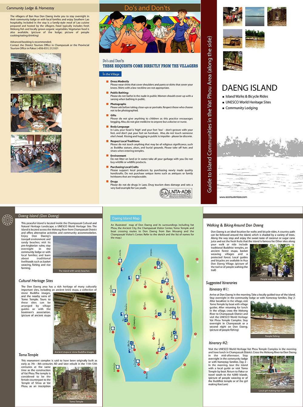
There has been no dam today in the Mekong River between the Golden Triangle (Northern Thailand) and the Mekong Delta in southern Vietnam. But now Laos is on the way to change this: Construction works for Xayaburi Dam have progressed. And a project for Don Sahong Dam in the Si Phan Don area in southern Laos has been launched. There is the fear, that these dam projects may hit the livelihood of tens of millions of people living along the Mekong. Therefore this blog starts a documentation about what is happening.


20.8.2014
Laos has suspended construction of its controversial Don Sahong hydropower dam on the Mekong River. This has been said by Lao ambassador Prasith Sayasith during a meeting with Cambodian Deputy Prime Minister Hor Namhong, as Radio Free Asia reports.

3.4.2014:
Construction of the Xayaburi Hydro-power plant, the first dam is now 23% complete.
Lao media report this according to Bangkok Post. It is "on track to be operational in 2019 as planned," the Vientiane Times reported. 39 Organizations based in Cambodia, Vietnam, Thailand and Australia have issued one more Plea to Halt Xayaburi Dam in Laos as Chiangrai Times reports.

39.3.2014:
Protest against Don Sahong Dam in Si Phan Don
About 600 people are scheduled on Saturday to start a four-day protest that will include marches and boat trips to call for construction of the controversial Don Sahong dam on the Cambodian-Lao border to be halted, reports The Cambodia Daily. The highly sensitive and critically endangered freshwater dolphins in this area will likely be extinct if dams such as the Don Sahong go ahead, the WWF has said. See also video by WWF.


3.10.2013: The Government of Laos notifies the Mekong River Commission of its intention to construct the Don Sahong Dam. In June 2008 the Malaysian Mega First Corporation Berhad (70 percent of the shares) had formed a joint venture with IJM Corporation (30 percent) for the project development. The Don Sahong Dam is a Run-of-the-river hydroelectricity facility. It would be located at the downstream end of the Hou Sahong channel between Don Sahong and Don Sadam islands. The dam's height would be between 30 and 32 metres. It would have a capacity of 260 MW. Most of the produced electricity would be exported to Thailand and Cambodia. Many independent fisheries experts fear that the dam would have a serious impact on fish migration as the channel is the only one within the Khone Falls complex that is passable to migratory fishes in the dry-season, and it is the major migration channel year-round. There is grave concern among environmentalists that the dam will jeopardise fish catches in Cambodia's Tonle Sap lake, as The Nation reports. Read background on thediplomat.com.

18.1.2013:
Vietnam and Cambodia tell Laos to stop $3.5bn Mekong River dam project
Vietnam urged Laos to halt construction of a $3.5bn (£2.2bn) hydropower dam on Mekong River pending further study. The Mekong River commission (MRC), made up of member states Vietnam, Cambodia, Laos and Thailand, held a three-day meeting in northern Laos to discuss river development projects. The dam in northern Laos, the first of 11 planned for the lower Mekong River, threatens the livelihood of tens of millions who depend on the river's aquatic resources, activists say. Read more on guardian.co.uk.

8.12.2012: Xayaboury project differs from other dams
The Xayaboury hydropower project differs significantly from earlier hydropower projects in the region. Director General of the Department of Energy Policy and Planning, Dr Daovong Phonekeo, says that the Xayaboury dam will be the first run-of-river scheme to be built on the Mekong River and the first in Laos. In a run-of-river scheme there is no high dam storing enormous amounts of water. The water is kept within the river’s course and the level is raised only minimally to allow for the passage of ships and fish migration. As no reservoir is created, the daily flow of water through the dam is used for power generation throughout the year. The river’s hydrology, or seasonal flows, will continue as normal because the same volume of water that flows upstream will flow downstream. Fish passage and sediment flushing systems designed for the Xayaboury dam are based on natural river conditions. “With respect to Xayaboury, we have conducted thorough and detailed studies to improve fish passage in a number of ways and we have incorporated sediment flushing systems and other mitigation measures as well,” Dr Daovong said. Based on recommendations from independent consultants Poyry and Compagnie Nationale du Rhone, the fish ladder has been extended to ensure the maximum number of fish species will be able to pass through the dam. In addition, the navigation locks will function as a fish lift, an additional fish tunnel will be built and fish-friendly turbines are to be used. Meanwhile a fish hatching station will complement the lift, ladder and tunnel to ensure that any endangered fish species survive. Sediment transport through the Xayaboury dam has been designed in accordance with recommendations from Compagnie Nationale du Rhone, which has been operating 19 run-of-river hydropower stations on the Rhone River for the last 50 years. There are are many successful examples of run-of-river or “low-head” dams especially in Europe. The Rheinfelden power plant, 25 km east of Basel, Switzerland, harnesses the power of the Rhine River. The Fredenau hydroplant near Vienna, Austria, is the latest and largest hydropower facility to be built on the Danube River. Both are state-of-the-art and feature effective fish passage facilities. Read more on Vientiane Times.

3.12.2012
The Chinese-made Stung Atay dam in Cambodia collapses while under construction.
The Associated Press reports that the Saturday collapse occurred at the Stung Atay Hydroelectric Project, a $255-million dollar dam on the Atay river, funded by the Chinese state-owned China Datang Corporation and situated in Cambodia’s Cardamom Mountains. The construction of the 120 megawatt Stung Atay hydropower dam began in 2008 and is scheduled to be completed in May 2013. Read more on Living in Phnom Penh.

25.11.12: Vientiane says sorry for broken Xayaburi ground
Bhuddhist monks led almsgiving and chanting in the Lao valley, where the dam will soon form a concrete barrier across the mainstream Mekong River. "Normally, before we start blasting the riverbed, the Lao tradition is to ask the spirits in the area to forgive us for disturbing the river," Viraphonh Viravong, Laos' Vice-Minister of Resources and Mining, said. The Thai company Ch Karnchang will develop and co-own the dam with the Lao government. The Electricity Generating Authority of Thailand (Egat) has secured a 28-year deal to purchase 90% of power generated by the dam. Bangkok Bank, Krung Thai Bank, Siam Commercial Bank, Krung Thai Bank, Tisco Bank and the Export-Import Bank of Thailand are financing the dam. The Xayaburi dam will be 40 metres high and 800 metres across, with no reservoirs. Read more on Bangkok Post. And read Media Kit on the Xayaburi Dam by internationalrivers.org.


Picture by International Rivers
Thai villagers protest against Xayaburi dam during Asia Europe Summit in Vientiane on 5 November 2012.

Picture by International Rivers
Lao Theung women of Ban Huay Song are panning for gold near Kaeng Luang. The income from this is meager, but the construction of Xayaburi Dam nearby shall make it vanish forever.


23.10.2012
Questions over China dams
Some questions remain about whether hydro dams on the upper Mekong River in China exacerbated conditions during Cambodia's devastating drought of 2010, environmental groups say, as China's dam program powers ahead. Last month the first power-generating unit was switched on at China's giant 262-metre tall Nuozhadu hydroelectric dam, which will be the largest on the river when completed in 2014. Research showed "water flow in the river's China section accounted for only 13.5 per cent of the river's total, making the country's hydropower development have little impact downstream", China Daily said. Ame Trandem, Southeast Asia program director for International Rivers, said, however, that China's section of the Mekong, known in that country as the Lancang River, provided as much as 50 per cent of the river's total water flow during the dry season. Read more on Phnom Penh Post.

17.9.12
Thai petition against Xayaburi dam
A conservation group submitted a petition with more than 9,000 signatures from people opposed to a controversial dam on the Mekong River to Prime Minister Yingluck Shinawatra yesterday, demanding the Thai government cease support for the Xayaburi Dam. Read the news and comments.

Map of Mekong dam projects


16.1.2012:
Portland State University researchers expose environmental costs of building Mekong River dams:
Their study also put new dollar signs on the potential cost to the environment and traditional fisheries — figuring the net economic impact of a string of electricity-producing dams could range from a gain of $33 billion to a loss of $274 billion.


4.1.2012
China has built dams:
Meanwhile China has been building a series of dams on the upper Mekong especially in Yunnan province. They say that the dams in Yunnan will have a positive environmental impact and will help control flooding in the downstream. However, the downstream countries have expressed that the dams will severely restrict the migration of fish and will have drastic impacts on the hydrological flow of the river. (..) China has never joined Mekong River Commission and it still refuses to join.


29.12.2011:
New dam project underway in Laos’ Luang Prabang province:
Construction of a 308-million-dollar hydropower dam on the Khan River in Laos’ Luang Prabang province is 15 per cent completed and should be operational by 2015, reports said Wednesday. A total investment of about 2.4 trillion kip (308 million dollars), of which 95 percent had been borrowed from the Exim Bank of China. China’s Sinohydro Company is handling construction of the dam, which will be 136 meters high and 365 meters long, creating a reservoir of 30.5 square kilometers with a capacity to store 686 million cubic meters of water, the newspaper reported.


19.12.2011
Don’t dream the Xayaburi hydropower project is over. It’s not dead yet. Laos keeps its hydropower hopes alive:
The agreement to further study the dam constitutes a time-buying tactic for more negotiations among the four countries. As long as the project is not shot down, there is a chance it will go ahead. The message from Laos to the other three countries in the meeting has given an open door for Vientiane to keep on fighting for it. (Bangkok Post)


15.12.2011:
Thai Utility Commits to Purchase Power from Xayaburi Dam: Thai Senators are investigating whether the Electricity Generating Authority of Thailand (EGAT) violated the Thai government’s instructions by signing an agreement to purchase power from the controversial Xayaburi Dam before it is approved by the Mekong River Commission’s member governments. Read more on internationalrivers.org.


9.12.2011
Xayaburi Dam Stopped for Now
: Environmentalists appear to have been handed a second rare victory in Southeast Asia with Thursday’s decision by the Mekong River Commission Council to delay for an uncertain period the construction of the Xayaburi Dam on the Mekong River 100 km. inside Laos. The council, comprising water and environment ministers from Cambodia, Laos, Thailand and Vietnam, agreed at a meeting in Siem Riep, Cambodia, to seek international support to produce a more complete study of the dam. However, the Xayaburi Dam, 810 meters wide and 32 meters high, could well be harder to stop although at least 263 NGOs from 51 countries and thousands of people in the area have urged that it be cancelled. Its primary objective is to generate foreign exchange earnings for financing socio-economic development in Laos. Preliminary construction has already begun, with access roads and the dam foundation already in place, according to Ame Trandem, the Thailand representative for the Berkeley, Calif.-based Save the Rivers environmental group. Read more on asiasentinel.com.


7.12.2011
Cambodia opens Kampot Hydro Dam
Energy-starved Cambodia on Wednesday opened Kamchay dam, the country's largest hydropower dam to date, a multi-million dollar Chinese-funded project, which cost more than $280 million, in southern Kampot province. US-based campaigners International Rivers said the Kamchay dam had destroyed hundreds of hectares of forest and farmland and warned it would have a negative impact on fisheries and on local people's livelihoods. Read more on AFP. The dam is invested and constructed by the Sinohydro Corporation. The project is a concessional contract of a 44-year build- operate-transfer (BOT) with Cambodian government. Of the period, 4 years for construction and 40 years for operations, it said, adding the electricity is sold to the state-owned Electricity of Cambodia. The Kamchay hydroelectric dam is one of the five dams with a total capacity of 915 megawatts invested by China in the total investments of 1.6 billion U.S. dollars. The other four dams being constructed are Kirirom III hydropower dam with the capacity of 18 megawatts, Tatay river hydropower dam with the capacity of 246 megawatts, Atay hydropower dam of 120 megawatts and Russei Chrum Krom with the capacity of 338 megawatts, according to the reports of Cambodia’s Ministry of Industry, Mine and Energy. Read more on Living in Phnom Penh.


5.12.2011
Thailand’s Role in the Xayaburi Dam: Not only does Thailand plan to purchase 95% of the dam’s electricity, but Thai companies are building the dam and four Thai banks will finance the project. Without Thailand’s help, the Xayaburi Dam would not exist. Read more on chiangraitimes.com.


12.9.2011:
In Laos, a tale of two dams: In an isolated valley in central Laos where people live mostly in wooden stilt homes accessed by dirt roads, the thick concrete slabs and towering mechanical apparatuses of the Nam Theun 2 dam stand at odds with their surroundings. The Laos government and World Bank pledged to resituate displaced families with enough farmland and credit that their yearly income would double — a benchmark that has nearly been reached, they say — and many villagers were given a say in the process, according to developers.
“We realize it’s much cheaper to develop [on] a larger scale and use the export earnings to subsidize rural electrification,” said Viraphonh Viravong, director of the Laos Department of Electricity and the government’s point-person for the Xayaburi dam. “That’s why the project started to get bigger and bigger.”
Plentiful rivers, mountains and rainfall collectively give Laos high hydropower potential, and its more industrialized neighbors Vietnam and Thailand are eager buyers of electricity; the government has already pledged to sell 95 percent of the electricity generated by the Xayaburi dam to Thailand. Read more on globalpost.com

17.4.2011
Decision Looms for Laos Dam, but Impact Is Unclear: The news media in Vietnam, which normally hew to the government’s line, have been unusually critical of the Xayaburi dam project. Farmers in the Mekong Delta fear that an accumulation of dams on the river could reduce the volume of water that reaches Vietnam, exacerbating the problem of saltwater seeping into farming areas from the sea. The plan calls for a generating capacity of 1,285 megawatts, enough to power a small or medium-size city. The dam, which is situated between steep hills and will span a distance of about eight football fields, will have the same impact as a “natural waterfall,” the government said in response to the report by the Mekong River Commission. The government says it plans to become “the battery” of Asia with a total of 70 hydroelectric projects, 10 of which are already in operation. Read more on nytimes.com.

Xayaburi dam work begins on sly: An investigation by the Bangkok Post Sunday which visited the area surrounding the Xayaburi dam on the Lower Mekong River last week found major road works under construction and villagers preparing to be relocated. At Ban Talan, villagers said Lao authorities had come to see them. They were told they would have to move but no date was specified. The villagers said they were promised new concrete houses allotted by the government on a nearby mountain.(Bangkok Post)


10.1.2011
The Mekong River: To dam or not to dam? Xayaburi dam is the first of 12 proposed hydropower dams on the Mekong. The dams “will have profound negative consequences for people, agriculture, fisheries, and riverine ecology,” said Smithsonian Tropical Research Institute research associate Tyson Roberts, who has studied Mekong fishes for over 40 years. The Mekong harbors a rich diversity of animal species such as the critically endangered Mekong giant catfish and Irrawaddy dolphin. With an estimated annual harvest of approximately 2.2 million tons of fish, the Mekong also ranks as the world’s largest inland fishery and impacts the livelihoods of the nearly 30 million people who live within 10 miles of its lower stretches. Up to 70 percent of fish species in the Mekong migrate long distances to feed and spawn, and dams would both physically block their upstream journey as well as change the environmental signals that trigger migration, Eric Baran explained in a paper published in the environmental journal AMBIO last June. Altering the Mekong’s flow could have a disastrous effect on agriculture. Any change in sediments and nutrients transported by the river can change rice yields, Philippe Cacot explained. Manipulating the river’s flow could also allow for salt-water intrusion in the Delta, another major threat to agriculture. (scienceline.org)

25.4.2004
Dammed and dying: The Mekong and its communities face a bleak future
One of the world's greatest rivers has been reduced to a trickle in places by a series of giant Chinese dams. The Mekong's downstream countries, which are almost completely dependent on the river and its tributaries for food, water and transport, fear that China's plans for a further six major dams on the river could be disastrous. The Manwan hydroelectric dam across the upper Mekong, finished in 1996, has been frequently blamed by Thailand and other countries for reduced fishing and also for causing flash floods when water is released unpredictably. A second giant dam, at Dachaoshan, is almost complete but is said to be already affecting the river flow, and a third is due for completion in 2012. Read more on guardian.co.uk.


See also: http://www.savethemekong.org